

Cox Mountain and Fanny’s Ford Trails
Steep climb and descent of over 250 feet from the Eno to Cox’s Mountain…
Entrances:
This is the Eno entrance that is best marked. From I-85 take exit 173 onto Cole Mill Road north. The road ends at the park. Stop for trail maps outside the office on the right near the park entrance. Leaving the office, stay straight until the parking area for this set of trails. Google maps gives good directions here as well.
Environment:
When done in full, Cox Mountain is a suprisingly difficult amateur hike for this area. Fanny’s Ford is an easy, beautiful addition. Even if a strenous climb is not in your plans, most of the hike’s highpoints can be experienced anyway. Click on the map below to see the trail in google maps:

Coming out of the parking lot, the trail is initially paved sidewalk. A large area of picnic tables are on the right. The trail continues into the woods and takes a pretty rapid descent to the riverside. After about 0.2 miles, the trail shadows the river briefly before crossing a swinging bridge.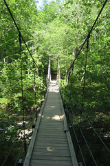 This area is often populated with kids exploring the bridge and playing in the river. Other small unmarked trails allow for further river exploration in this area. This is as far as a lot of the park’s visitors go in exploring this area.
Continuing past the bridge, the Cox Mountain trail forks. Taking the left (western) trail will get the strenuous ascent part of the trail over while your legs are still fresh. Under the canopy, interesting stacks of rocks can be seen on the “mountain”.
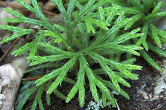
 My hiking partner for this trip, Mike, speculated that this might have been some way that land was marked in previous times. Around the trail interesting pieces of stone such as quartz are easily found. A few scattered benches allow for rest, but for the most part, the mountain hike is simply a workout.
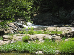
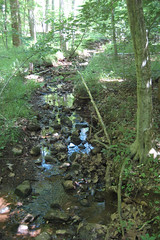
As the trail returns near the previously described fork, the take off to the Fanny’s Ford loop can be found. 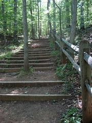 After a brief flat hike through the woods, the trail follows a wonderful area of river. Be watching for a small unmarked fork near the river that takes the hiker near a tiny waterfall. I would have missed it except we could hear the roaring of the water.
This trail ends on an old coach road at Few’s Ford. Both children and adults alike can enjoy the shallow moving water while imagining horse-drawn carriages crossing the river here many years ago. Completing the loop will bring you back to the swinging bridge and toward the parking area.
Casual hikers may wish to avoid the steep mountain climb and just take the trail straight to Fanny’s Ford Trail. This would be a kid-friendly hike that hits most of the beauty of the hike.
Positives:
- The Cox Mountain ascent/descent is rare challenging hike for this area
- However, the difficult areas can be avoided for family fun
- Fanny’s Ford, small falls, and river near the bridge is ripe for child’s play
- Swinging bridge is enjoyed by all
- Superb trail care and markings
Kid’s Interests:
- Multiple areas for water play
- Swinging bridge
- Water fowl, turtles, amphibians
- Small falls
- Fanny’s Ford
Details:
Cox Mountain Trail:
- Difficulty: Moderate
- Surface: Natural
- Bicycles: No
- Length: 3.6 Miles
- Blazes: Blue Dots on Trees

Fanny’s Ford Trail:
- Difficulty: Easy
- Surface: Natural
- Bicycles: No
- Length: 0.9 Miles
- Blazes: Purple dots on Trees
Maps/Links:
- Google Maps/Earth Map of Cox Mountain and Fanny’s Ford Trails
- KML: Cox Mountain and Fanny’s Ford Trails
- Eno River Association: Trails of Western Eno River
- PDF: Western Eno River Trails Printable Map
Photos:
|
|
June 4th, 2007 at 8:27 pm
Davak, this is awesome. What a great way to share your outdoor excursion, and an inspiration for me to get back to one of my favorite areas of this region.
September 15th, 2007 at 9:56 am
[…] the trail along the river, you will mirror the Fanny’s Ford trail for a bit. This includes crossing a wooden overlook that views the small but roaring […]