

Occoneechee Mountain
Hiking the highest point in Orange County and exploring the abandoned pyrophyllite quarry
Entrances:
To reach Occoneechee Mountain State Natural Area from I-85, take exit 164. Travel north on Churton Street, and turn left at the stoplight onto Mayo Street. At the next stop sign, turn left onto Orange Grove Road.  Turn right onto Virginia Cates Road, and follow the signs to the parking area. (Directions/Map in PDF format.)
Environment:
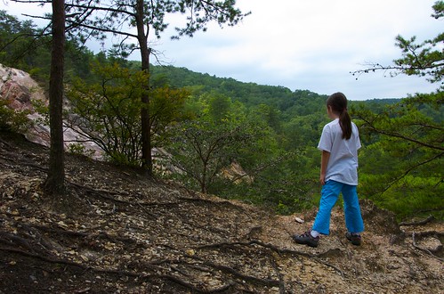
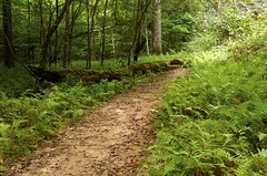
From the parking lot, you can hit either trail head for the Occoneeche Mountain Loop Trail. All of the side trails including Brown Elfin Knob Trail, Summit Trail, and Overlook Trail come off the northeastern part of this main loop. These side trails highlight some of the main aspects of the mountain and allow for a shorter hike. Trail maps are available from the parking area. For reference the northeastern start of the loop starts near the easily seen Ranger’s Residence. The western trail head of the loop starts past the public restrooms. On our afternoon we hiked around the entire loop trail and did not tackle the shorter side trails. I’ll be describing the trail as starting from the northeast trail head.
View Occoneechee_Mountain in a larger map
 The trail starts with the fishing ponds on the right and veers off into the shades of the mountain forest. The initial climb peaks near the Brown Elfin Knob (767ft elevation) . The Brown Elfin Knob Trail forks off here and can be taken to the Summit Trail for a quicker hike to the Occoneechee Mountain Summit. We ignored these side trails on this trip.
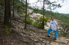
 Climbing down the knob, the trail enters the power line cuts that borders the northern and eastern perimeters of the park. Although a bit unnatural, the power line cut is a good opportunity to appreciate how high the mountain is compared to the rest of the area. Continuing around the mountain, the trail next passes the Overlook trail. This internal side trail gives an top down view of the abandoned quarry. We bypassed this knowing we would have other opportunities as the loop continued.
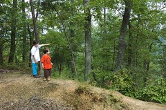
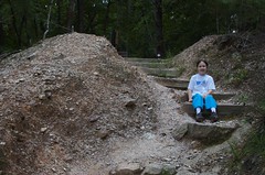
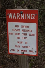 After another short hike along a power line cut, numerous warning signs mark a short, unmapped quarry trail. The views of the quarry here are very impressive. Children in this area should be watched closely as one wrong step could equal disaster. A bit further down, the trail opens up into the bottom of the quarry. Kids will love exploring the large boulders and rocks left from the large rockslide in 2001.
Leaving the bottom of the quarry will lead to the portion of the trail that parallels the Eno River. Near a small bridge take the time to explore the natural drainage from the quarry.  The pyrophyllite mineral found here is often used in talcum powder. The soft talc-like quarry silky residue can be found on rocks in this drainage areas. The many flat smooth stones here are also great for rock-skipping lessons with the kids.
The western and southern sections of the loop are mildly strenuous as it wraps up and around the mountain. At one point the loop approaches the mountain summit (867 ft. elevation). The sound of Interstate 85 near the trail’s end signals your return to civilization.
Quarry History and Geology
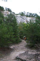 The quarry was started prior to the Civil War and was used to create railways in the state. It operating as the Southern Broken Stone Company until the early 1900s. The white face of the quarry is formed by the sericite, quartz and pyrophyllite minerals found in this area. The talc-like pyrophyllite continues to be an important industrial mineral. In fact, a nearby active modern quarry can be seen while hiking in the area. North Carolina remains a leading miner of pyrophyllite in the United States.
More information about the geology and minerals of the Occoneechee mountain can be found in this article: How Did Occoneechee Mountain Form? Examples of minerals in the area can be found on this page: The Rocks and Minerals of Occoneechee Mountain
Details:
Occoneechee Mt. Loop–
- Difficulty: Moderate to strenuous
- Surface: Natural
- Bicycles: No
- Length: Approximately 3 miles
- Blazes: Orange/Red dots
Maps and Links:
- Google Maps: Occoneechee Mt. Loop Trail
- Official Trail Map of the Occoneechee Mountain State Natural Area (pdf)
- KMZ of Occoneechee Mountain
- Images from Occoneechee Mountain Hike
|
|